GBM Blog
Mount Kenya 101: a rich history that you will experience with our Climb Mount Kenya Challenge!
 Researched and written by Samantha Wilde.
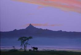
Standing just over 17,000 (5,199m) feet above sea level, Mount Kenya is the second tallest mountain in Africa after Mount Kilimanjaro. Mt Kenya is located on the equator in central Kenya and is an extinct stratovolcano that is thought to have risen over 23,000 ft (6,500m) before it erupted over 3 million years ago.
Today, Mount Kenya has been deemed a UNESCO World Heritage site for its beautiful glaciers, world class flora and fauna and breath taking views. Mount Kenya represents so much more than a beautiful National Park – It has a rich history. In Professor Maathai’s autobiography Unbowed, she describes the history of Mount Kenya from her rich cultural heritage and the changing relationship with the environment:
“For the Kikuyus, Mount Kenya, known as Kirinyaga, or “place of brightness”, and the second-highest peak in Africa, was scared place. Everything good came from it: abundant rains, rivers, streams, clean drinking water. Whether they were praying, burying their dead, or performing sacrifices, Kikuyus faced Mount Kenya, and when they built their houses, they made sure the doors looked toward it. As long as the mountain stood, people believed that God was with them and that they would want for nothing. Clouds that regularly shrouded Mount Kenya were often followed by rain. As long as the rains fell, people had more than enough food for themselves, plentiful livestock, and peace.
Sadly these beliefs and traditions have now virtually died away. They were dying even as I was born. When European missionaries came to the central highlands at the end of the nineteenth century, they taught that local people that God did not dwell on Mount Kenya, but rather in heaven, a place above the clouds. The proper place to worship him was in church on Sundays, a concept that was unknown to Kikuyus. Nevertheless, people accepted the missionaries’ worldview, and within two generations they lost respect for their own beliefs and traditions. The missionaries were followed by traders and administrators who introduced new methods of exploiting our rich natural resources: logging, clear-cutting native forests, establishing plantations of imported trees, hunting wildlife, and undertaking expansive commercial agriculture. Hallowed landscapes lost their sacredness and were exploited as the local people became insensitive to the destruction, accepting it as a sign of progress.” (Unbowed p. 5-6)
The environmental impact of changing cultural perceptions is evident in the Mount Kenya region. There is unsustainable deforestation from various illegal activities including firewood collection, charcoal burning, timber harvesting and agricultural land clearing has led to the loss of 30% of the forest cover. As a result, the Thuci and Ruguti rivers, whose catchment area lies around Mount Kenya, have significantly decreased in water volume.
As scientists have shown unsustainable industries, growing populations and increased demand for consumer goods have resulted in global climate change. As a result, mountain glaciers are shrinking at fast rates, threatening water supplies for millions of people and species. This is starkly evident on Mt Kenya where it is estimated that 92 percent of Mt. Kenya’s largest glacier, the Lewis Glacier, has disappeared over the last 100 years.
The Green Belt Movement takes part in a number of projects in the Mount Kenya region in order to curb environmental degradation and educate people on the linkages between environmental destruction and poverty. GBM communities form tree nurseries and plant seedlings on public lands, restore degraded forest areas, and private farms. Since 1977, GBM communities have planted over 40- million trees in Kenya to increase national forest cover and restore essential ecosystems. In order to increase its impact on ecosystem functioning, GBM has adopted the watershed approach, which targets vulnerable water catchment areas.
A watershed is a geographic area of land where rainfall drains to a common point on a stream, river, pond, lake or other body of water – preserving these areas is key for sustainable waterways. Furthermore by combining with GBM’s 10 step approach, GBM’s watershed approach builds a sense of community, helps reduce conflicts, increases participatory commitment and improves the likelihood of success for environmental programmes.
This year the Green Belt Movement has launched our Climb Mount Kenya challenge, giving our supporters the chance to experience the rich history of Kenya while supporting our work. The 10 day trip in October 2011 will take you to the top of Mt Kenya with experienced guides as well as on a Green Belt Safari where you’ll visit a GBM community to see our projects and the watershed approach in action. The money raised will go directly to GBM’s projects - the more money raised, the more GBM’s communities and their local environment will benefit. Check out our Trek Mount Kenya page for the complete itinerary and to sign up TODAY!
Photo source: BBC and pathwaysafricasafaris.com
Blog Archives
- December 2023 (1)
- December 2021 (1)
- November 2021 (3)
- October 2021 (2)
- April 2021 (1)
- March 2021 (3)
- February 2021 (1)
- January 2021 (4)
- March 2020 (3)
- February 2020 (1)
- November 2019 (1)
- September 2019 (5)
- May 2019 (2)
- November 2018 (2)
- September 2018 (4)
- June 2018 (2)
- April 2018 (1)
- February 2018 (1)
- September 2017 (1)
- July 2017 (2)
- June 2017 (1)
- May 2017 (1)
- April 2017 (2)
- March 2017 (1)
- November 2016 (2)
- October 2016 (1)
- August 2016 (4)
- July 2016 (2)
- June 2016 (4)
- May 2016 (2)
- April 2016 (2)
- March 2016 (1)
- January 2016 (3)
- December 2015 (3)
- November 2015 (1)
- October 2015 (1)
- September 2015 (1)
- August 2015 (1)
- July 2015 (2)
- June 2015 (3)
- May 2015 (1)
- April 2015 (2)
- March 2015 (3)
- February 2015 (2)
- January 2015 (1)
- December 2014 (3)
- November 2014 (3)
- October 2014 (3)
- September 2014 (2)
- August 2014 (4)
- July 2014 (3)
- June 2014 (4)
- May 2014 (2)
- April 2014 (3)
- March 2014 (7)
- February 2014 (2)
- January 2014 (3)
- December 2013 (1)
- November 2013 (4)
- October 2013 (3)
- September 2013 (5)
- August 2013 (2)
- July 2013 (3)
- June 2013 (3)
- May 2013 (2)
- April 2013 (4)
- March 2013 (2)
- February 2013 (5)
- January 2013 (3)
- December 2012 (2)
- November 2012 (2)
- October 2012 (2)
- September 2012 (2)
- August 2012 (3)
- July 2012 (4)
- June 2012 (4)
- May 2012 (2)
- April 2012 (2)
- March 2012 (3)
- February 2012 (2)
- January 2012 (2)
- December 2011 (7)
- November 2011 (1)
- October 2011 (2)
- September 2011 (3)
- August 2011 (3)
- July 2011 (4)
- June 2011 (3)
- May 2011 (1)
- April 2011 (3)
- March 2011 (3)
- February 2011 (2)
- January 2011 (1)
- December 2010 (9)
- November 2010 (2)
- October 2010 (1)
- September 2010 (2)
- August 2010 (2)
- July 2010 (1)
- June 2010 (5)
- May 2010 (3)
- April 2010 (4)
- March 2010 (2)
- February 2010 (1)
- January 2010 (2)
- November 2009 (1)
